gaysville gets on the map....
Moderators: SkiDork, spanky, Bubba
gaysville gets on the map....
https://www.facebook.com/killingtonreso ... 261204401/" onclick="window.open(this.href);return false;
mach es sehr schnell
'exponential reciprocation'- The practice of always giving back more than you take....
'exponential reciprocation'- The practice of always giving back more than you take....
-
yiddle on da fiddle
- Powderhound
- Posts: 1510
- Joined: Jun 1st, '12, 13:30
- Location: Like flies to $hit...EVERYWHERE!
Re: gaysville gets on the map....
must.....resist.....urge.......
- Attachments
-
- doucheville.jpg (31.85 KiB) Viewed 1278 times
Re: gaysville gets on the map....
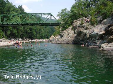
That's a pretty good video..................exactly where is that swimming hole, it looks like a really good place to swim?yiddle on da fiddle wrote:must.....resist.....urge.......
!!!!!!!!!! MAKE AMERICA LOVE AGAIN !!!!!!!!!!
Re: gaysville gets on the map....
right up 100 to rt 107 , left on bridge st to the gaysville post office.. park across the st at the old store...it's just reclaimed itself from the flood really...f.a.s.t. wrote:That's a pretty good video..................exactly where is that swimming hole, it looks like a really good place to swim?yiddle on da fiddle wrote:must.....resist.....urge.......
that's the rock ledge they are jumping off center screen just above the water line during the flood...

video of the same:
this is what it looks like from the water during normal water level...
mach es sehr schnell
'exponential reciprocation'- The practice of always giving back more than you take....
'exponential reciprocation'- The practice of always giving back more than you take....
-
Sgt Eddy Brewers
- Slalom Racer
- Posts: 1145
- Joined: Aug 24th, '11, 14:57
Re: gaysville gets on the map....
Irene did a fair amount of damage to that swimming hole...just not as deep at the tail end as it used to be. Still pretty but not as good a jumping spot as before. Other ledges just upstream at the next bend are also cool and there are serious beds of real cay at that spot.
The bridge on Blackmer Rd. further upstream has a really ballsy jump off bridge. About 35 feet high! Narrow slot under bridge is deep enough but if you miss the sweet spot you die(I think.) Too brave for me (I am a dad so that's my excuse) but I've seen a local backflip off it. Big balls.
The bridge on Blackmer Rd. further upstream has a really ballsy jump off bridge. About 35 feet high! Narrow slot under bridge is deep enough but if you miss the sweet spot you die(I think.) Too brave for me (I am a dad so that's my excuse) but I've seen a local backflip off it. Big balls.
Ski the edges!
Re: gaysville gets on the map....
That video looks like a pretty good day! I may just have to visit that swimming hole this summer. Any other nearby suggestions that are more recommended (Keeping in mind I have a 10 and 7 year old who don't need a massive cliff jump to keep them happy)?
Don't Killington Pico

Re: gaysville gets on the map....
Ditto on the kid question.boston_e wrote:That video looks like a pretty good day! I may just have to visit that swimming hole this summer. Any other nearby suggestions that are more recommended (Keeping in mind I have a 10 and 7 year old who don't need a massive cliff jump to keep them happy)?
Never argue with idiots. They will bring you down to their level, then overwhelm you with their experience.
"I have noticed that when you post, you often say more about yourself than the topic you chose to speak about." -The Suit
"I have noticed that when you post, you often say more about yourself than the topic you chose to speak about." -The Suit
-
Sgt Eddy Brewers
- Slalom Racer
- Posts: 1145
- Joined: Aug 24th, '11, 14:57
Re: gaysville gets on the map....
Actually the Gaysville site MH posted about is still a great swim site...one of the best nearby...just not as good a jumping site as it was pre-Irene.boston_e wrote:That video looks like a pretty good day! I may just have to visit that swimming hole this summer. Any other nearby suggestions that are more recommended (Keeping in mind I have a 10 and 7 year old who don't need a massive cliff jump to keep them happy)?
By the way, MH, that is an amazing video...hard to believe the river got that high. Nature can be fierce!
Ski the edges!
Re: gaysville gets on the map....
standing there watching that was something you don;t quickly forget... the big jump is maybe 20 ft, there, smaller 3-5 ft just upstream from there and a little beach if you cross the bridge to river rd or go down into the former campground...both of those "beaches" are shallow , wade in to the appropriate depth w slow current... shouldn't be a problem for a 10 and 7 yr old...there are also a couple tubing outfits nearby, white river yacht club ( the red building on the right as you come out of pittsfield, or white river tubing at the intersection of 100& 107 ( former Annabelles and site of the tweed river festival/no town festival)...Sgt Eddy Brewers wrote:Actually the Gaysville site MH posted about is still a great swim site...one of the best nearby...just not as good a jumping site as it was pre-Irene.boston_e wrote:That video looks like a pretty good day! I may just have to visit that swimming hole this summer. Any other nearby suggestions that are more recommended (Keeping in mind I have a 10 and 7 year old who don't need a massive cliff jump to keep them happy)?
By the way, MH, that is an amazing video...hard to believe the river got that high. Nature can be fierce!
madhatters live about 2 minutes from the swimming hole/gaysville PO, spent a lot of lunch hours cooling down in there when we built the madhatterdome... I really haven;t been down there much since irene, but in the last yr or two the river has resumed its course and the swimming hole is closer to its former depths...
I have a lot more pics and probably a couple more videos of the flood if anyone is interested, many don;t know but there was also a pretty significant flood event in 2007 on lilliebrook rd,( gaysville/bethel line) not as widespread as the irene flood but it also it destroyed roadway and houses...( r*ined a lot on my house project too...) I called my friends in CT that afternoon and said we'd be on the news that nite cuz I'd never seen r*in that hard for that long, not even during the windsor locks ct tornado on oct 4 1979, when my town was ground zero and eventually under national guard curfew....sure enough , we were...
someone was also talking about the swimming hole known as "deans bend" and the clay deposits there, legend has it that in the early 1900's people would come from miles around to slather themselves in that clay and bake in the sun....locals would likely get upset if I just disclosed the location of that swimming hole here, but it's probably public info somewhere anyway...
local legend bow thayer lives about 30 seconds away from that one and can be spotted there w his family on occasion...
anyone up for eclectic dining w vegan and vegetarian options combine w music, check out the Wild Fern ( just before the 100& 107 intersection) operated by heather lynn of rick reddington and the luv, rick is often there plying his trade or making pizzas while other musicians play outdoors on the patio...it's BYOB...
and coming this summer the stony brook tavern in the former peavine restaurant... s/b worth the trip for that once it opens...
if anyone's intending on heading down to the swimming hole, ( or the tavern when it opens) the hatters would be willing to come down off the hill and have a beer or two...PM us...
mach es sehr schnell
'exponential reciprocation'- The practice of always giving back more than you take....
'exponential reciprocation'- The practice of always giving back more than you take....
-
roundabout
- Bumper
- Posts: 523
- Joined: May 4th, '05, 18:50
- Location: Enfield C.T
Re: gaysville gets on the map....
This site might be helpful for finding local swimming holes, but I am not sure how often it's updated:
http://www.swimmingholes.org/" onclick="window.open(this.href);return false;
Kevin
http://www.swimmingholes.org/" onclick="window.open(this.href);return false;
Kevin
Re: gaysville gets on the map....
https://www.facebook.com/Tweed-River-Tu ... 499787849/" onclick="window.open(this.href);return false;
since they just posted this today on FB I'll share it here...
and for the non-FB crowd ( god bless you all )
)
http://www.tweedrivertubing.com/" onclick="window.open(this.href);return false;
since they just posted this today on FB I'll share it here...
and for the non-FB crowd ( god bless you all
http://www.tweedrivertubing.com/" onclick="window.open(this.href);return false;
mach es sehr schnell
'exponential reciprocation'- The practice of always giving back more than you take....
'exponential reciprocation'- The practice of always giving back more than you take....
-
roundabout
- Bumper
- Posts: 523
- Joined: May 4th, '05, 18:50
- Location: Enfield C.T
Re: gaysville gets on the map....
I am used to swimming/paddling the White River per Irene. IMO it's depressing looking now, kind of looks like a dredge went through the whole river. I guess it will take a long time to look natural again. All the kayaking spots have been re-arranged and the guide books are good for the fireplace.
Re: gaysville gets on the map....
yep looks like rocky mtn winter drainage now, big wide swaths with a small trickle running thru the middle of it...it IS reclaiming itself though, just takes time...roundabout wrote:I am used to swimming/paddling the White River per Irene. IMO it's depressing looking now, kind of looks like a dredge went through the whole river. I guess it will take a long time to look natural again. All the kayaking spots have been re-arranged and the guide books are good for the fireplace.
mach es sehr schnell
'exponential reciprocation'- The practice of always giving back more than you take....
'exponential reciprocation'- The practice of always giving back more than you take....