Page 2 of 2
Re: New Trail Map?
Posted: Nov 10th, '17, 15:11
by Seacoaster
I print trail maps for many of the resorts in the east. This change over is a no brainer for the resorts. They can edit and update the maps so much easier for things like trail or sponsor changes. These maps are also more accurate and better for the end user.
Re: New Trail Map?
Posted: Nov 10th, '17, 16:47
by Skier77
Is stitchline headwall a trail now? Also from the map it looks like they moved the official Devils Den entrance up a bit. Last thing is that it now looks like they have labeled the stash woods as woods now
Re: New Trail Map?
Posted: Nov 28th, '17, 19:03
by snoloco
Normally I'm a fan of James Niehues maps, but I think the new one here is much better and easier to read. They "fattened out" the various locations where trails come together and made it so much easier to read. And I agree with the old one it appeared they were photoshopping the changes into it rather than getting the whole thing redrawn, which is really expensive.
Mount Snow's new VistaMap has no inset for the North Face. Only for Sunbrook. The old James Niehues map had insets for both.
Re: New Trail Map?
Posted: Nov 28th, '17, 20:23
by brownman
Map indicates Vista Bar is now Brat Haus.

Re: New Trail Map?
Posted: Nov 29th, '17, 00:57
by Fusion Zoner
Skier77 wrote:Is stitchline headwall a trail now? Also from the map it looks like they moved the official Devils Den entrance up a bit. Last thing is that it now looks like they have labeled the stash woods as woods now
Devil's Den entrance does look to be a little bit higher than last year but some years ago there was an entrance all the way at the top of Bear. When you got off the chair and turned left to head to OL or DF, if you kept heading toward the woods to the right of the lead-in to OL headwall, there was a trail sign for Devil's Den. You dropped into the trees there and the main line skirted around the top of DF and came down to what is the marked Devil's Den today. Maybe they eliminated the top entrance after some geniuses stayed too far right and ended up going down you-know-where. I've cut and pasted a snippet of the Bear map from 2006-2007 which shows pretty much what I'm saying.
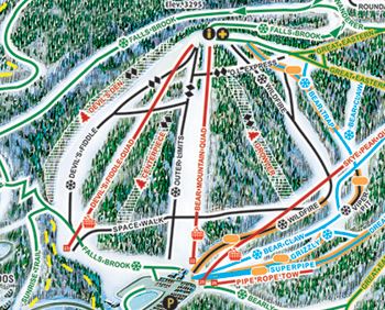
- Bear 2006-2007.JPG (53.95 KiB) Viewed 374 times
Re: New Trail Map?
Posted: Nov 29th, '17, 06:57
by hillbangin
What's a trail map?
Re: New Trail Map?
Posted: Nov 29th, '17, 15:11
by RustyK
brownman wrote:Map indicates Vista Bar is now Brat Haus.
Must be like the Dog house now.
Paul is gonna be serving up pork products!
Re: New Trail Map?
Posted: Nov 29th, '17, 21:29
by brownman
I'll ask him to serve you a waffle

Hey .. sooner later ..
ps.. anybody here the day those knuckleheads stole a box of trail-maps, somehow got them on the K1 and proceeded tossing them down on Cascade? It was a friggin mess over there. Biodegradable maps soon followed. Preserve the Basin
