johnny the jibber wrote:talking skiing and riding in the off season is almost taboo around here, so ive noticed. the snow will fly soon enough, and skiing and riding will still be off topic, but we can still talk stocks, fishing, mtn biking, just NO snow sports...
friggin admin nazis..
will it ever end?
Now you pissed me off. My kid just finished his newest potato cannon. This sucker works off propane. You sir, are dead-ass meat.
KnuckleDragger wrote:Well that lower part to Sante Fe sounds like fun. Anyone know how much snowcat traffic that lower part of the trail gets right after a good dump? Is it likely to stay untracked for a few days or do the cats go back and forth on a daily/regular basis?
hmmm.....since I live at Mt Green, maybe that's the new route home. Gotta be more fun than taking snowshed home.
This sounds like it would end up being real close to our condo development. It would be interesting to ski home from there one day. The only problem would be having to get a ride back to Pico to pick up the vehicle we drove over to begin with.
This sounds like it would end up being real close to our condo development. It would be interesting to ski home from there one day. The only problem would be having to get a ride back to Pico to pick up the vehicle we drove over to begin with.
johnny the jibber wrote:talking skiing and riding in the off season is almost taboo around here, so ive noticed. the snow will fly soon enough, and skiing and riding will still be off topic, but we can still talk stocks, fishing, mtn biking, just NO snow sports...
friggin admin nazis..
will it ever end?
Now you pissed me off. My kid just finished his newest potato cannon. This sucker works off propane. You sir, are dead-ass meat.
KnuckleDragger wrote:Well that lower part to Sante Fe sounds like fun. Anyone know how much snowcat traffic that lower part of the trail gets right after a good dump? Is it likely to stay untracked for a few days or do the cats go back and forth on a daily/regular basis?
hmmm.....since I live at Mt Green, maybe that's the new route home. Gotta be more fun than taking snowshed home.
This sounds like it would end up being real close to our condo development. It would be interesting to ski home from there one day. The only problem would be having to get a ride back to Pico to pick up the vehicle we drove over to begin with.
It is. About halfway between your place and mine. Actually easier for you since it's downhill for you.
What is not possible is not to choose. ~Jean-Paul Sartre
This sounds like it would end up being real close to our condo development. It would be interesting to ski home from there one day. The only problem would be having to get a ride back to Pico to pick up the vehicle we drove over to begin with.
3 of us took the snowcat trail from pico to the swirl woods. I don't remeber if it was last year or the year before. Parked at RH, took the bus to pico, rode there for a bit, then took the trail back to RH.
2 of us were on snowboards... I don't actually remeber it being bad, had to carry a little bit of speed but there was no pushing involved on the board. There was decent show cover at the time.
Got to where the fork was, started hiking back up... got lazy and jumped into the woods. Woods there are fun, but tight, and we ended up part way down the ravine... so we had to hike out sideways for a while... ended up coming out on that mini terain park.
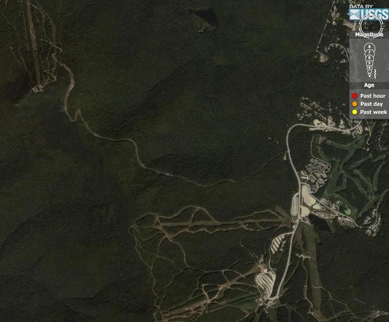
Pico on the left, K on the right. Interconnect in the middle
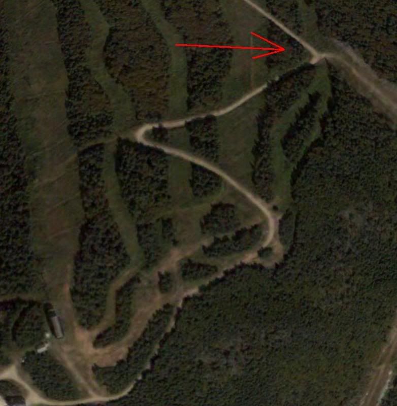
Close-up of entrance to Interconnect (elevation 3635')
Drops you off accross the street from Sante Fe at about 2131'
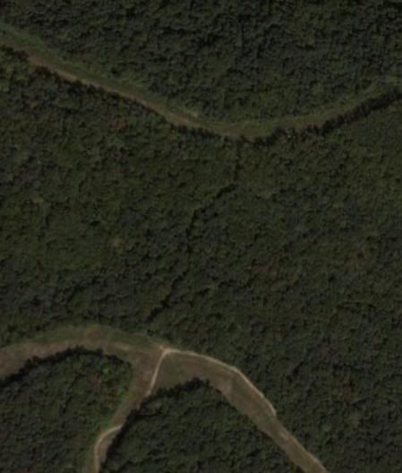
There appears to be a trail that connects Rams head (bottom) to the connector trail (above). The trail is relatively flat, starting at 2774' on the connector side and drops you off at 2820' onto Swirl via Ramshead.
It's doable I think ... sorry if this was already covered
Last edited by XtremeJibber2001 on Oct 2nd, '06, 13:21, edited 1 time in total.
XtremeJibber's "Close-up of entrance to Interconnect (elevation 3635')" overhead seems to show the Pico-side entrance as being pretty easy to get to.
It's the same cross-Pico trail (Easy Street?) that cuts over to the Birch Glades.
It looks like you just go all the way skier's right instead of left to the Glades/Pike/etc.
jon4snow, can you confirm the interconnect entrance at the same elevation as this trail? Is there any hiking involved from the Pico side?
Keithus wrote:XtremeJibber's "Close-up of entrance to Interconnect (elevation 3635')" overhead seems to show the Pico-side entrance as being pretty easy to get to.
It's the same cross-Pico trail (Easy Street?) that cuts over to the Birch Glades.
It looks like you just go all the way skier's right instead of left to the Glades/Pike/etc.
jon4snow, can you confirm the interconnect entrance at the same elevation as this trail? Is there any hiking involved from the Pico side?
That be the place. You taverse skiers left as far as you can and you will come upon a road which is roped off for the interconnect used for equipment.
Skiing down Pico you want to stay to your hard right. It's down hill to the access road for the most part. Not sure how easy it would be to traverse from the interconnect to Rams head tho because it seems rather flat. Someone wanna bike up there and give us feedback haha!?